Mapping applications
![]()
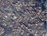
Basic mapping, town and country planning mapping, urban or telecommunication mapping are one of the most important of the civil application domains of OREFEO. The users are institutions (geographical institutes, technical services of administrations, ...) or private companies (research consultant, civil engineering companies, telecommunication operators, ...).
The products needed for this kind of applications are ortho-images, land use maps, topographic products (maps or databases) or altimetric products (Digital Terrain Models or Digital Height Models). To get this kind of products, the ORFEO system requires stereoscopic capabilities and the possibility to realize radar interferograms.
ORFEO mission will mainly concentrate on urban or peri-urban sites in complement to the SPOT 5 mission, for which a sub-metric resolution is needed. Radar data will be used to replace the optical data on sites with persistant cloud cover.
The ORFEO mapping mission is designed as a complement to the use of aerial photography, specially for a frequent update of information on small sites (when the use of airplanes is penalized by a fixed cost of use), and on region difficult to access.
For more information: Mapping