Applications
The Pleiades requirements were analysed by CNES with the help of the community of users. For this purpose, the main french players in the field of Earth Observation made their contribution, both as user organisations (IGN, BRGM, INRA, CNRS), or as services providers (like SPOT IMAGE, SCOT, ACRI).
The results and recommandations derived from forums with different communities of users, organised by the Ministry of Education, Research and Technology (MENRT) as part of the "Space & Society" meetings were also taken into account. Similarly, the needs of the European Commission in term of geospatial and environmental information, particularly those expressed by means of the GMES initiative, were also been taken into consideration.
The CNES analysis was confirmed by the analisys performed by ESA for the ERSIS study conducted by leading European industrialists and by that of the italian space agency (ASI), for its Cosmo-Skymed project.
Lastly, two seminars were organized by CNES in March and May 2000, to confirm the results obtained.
These analyses demonstrated the need for an optical and radar metric resolution observation system to detect, recognize and identify interesting targets or objects and their evolution. Italy and France decided in 2001 to join their effort to develop such a system named ORFEO (Optical and Radar Federated Earth Observation) through a governmental agreement signed in January 2001 in Turin.
ORFEO is a dual mission, able to satisfy both defence and civilian objectives.
The targeted acquisition capabilities with high resolution and high repetitivity of ORFEO make it a particularly well adapted system for defence or civil security missions, as well as for critical geophysical phenomena survey such as volcanic eruptions which require a prioritarian use of the system's resources.
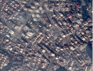
Moreover, the spatial resolutions and the stereoscopic or interferometric acquisition capabilities of the ORFEO sensors make it a system adapted to detailed mapping, specially in urban area, that can be used in complement to aerial photography.
Even if the spatial cover of the ORFEO optical sensors limits their use to the extensive characterization of targets with fast evolution (agricultural production for example), this system should complete the information supplied by other sensors, such as SPOT 5, for applications such as forestry, geology and marine environment, by supplying information with a better spatial resolution and three-dimentional characterization capabilities of the surfaces.