Events Archive
Events 2013
11/2013: Pléiades: towards a new radiometric model of the Moon?
Thanks to its total lack of atmosphere and the perfect stability of its surface and thus optical properties, the Moon constitutes an ideal calibration site for Earth observation missions for which the radiometric quality of the data is crucial. In the framework of the PLEIADES 1A and PLEIADES 1B in-flight calibration, studies took place in order to determine the calibration precision that could be reached from the acquisitions realized during the different lunar cycles. The POLO data set (Pléiades Orbital Lunar Observations) was born: over 1000 images of the Moons acquired over 6 months for viewing angles varying from -115° to +115° (0° corresponding to the full Moon, 180°, to the new Moon).
![]()
The Moon seen by Pléiades
The short term objective is now to use this POLO data set to improve the ROLO lunar model (Robotic Lunar Observatory), developped by USGS (United States Geological Survey) which is internationally accepted and used by every space agency for the calibration of satellite which are able to aim at the Moon. This new model should then be available to the international community through our participation to the GSICS (Global Space-based Inter-Calibration System).
Read the complete article.
Download the presentation
EVENTS 2012
12/11/2012:First images taken by Pléiades-1B Pléiades 1B
Pléiades 1B observation satellite from CNES, French space agency, has just delivered its first images after being sent in orbit on December 2, 2012 by a Soyuz launcher, from the Guiana Space Center.
Developed under CNES responsibility, Pléiades is a dual Earth observation system at very high resolution, meeting the needs of civil and Defense users.
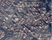
This system is composed of a constellation of two identical satellites, Pléiades 1A and 1B, built by Astrium, on the same orbit to guaranty a daily revisit capability all over the world. Pléiades satellites supply images at 70 cm resolution, resampled at 50 cm. They give an ideal detail level for mapping the most dense urban areas as well as for precision applications (crisis areas monitoring, mining or petrol exploration, marine monitoring, agriculture...). Their unequalled agility, enabling to minimise the programing conflicts, and their multiple acquisition modes (stereo, mosaics, corridor, etc.) make this constellation particularly reactive to the users specific requirements.
The images acquired by the two Pléiades satellites are collected by users centers, in Torrejon (Spain) and Creil (France) for Spanish and French armies, and in Toulouse by Astrium Services, which is the exclusive distributor for civil users.
![]()
LORIENT - France - Credits: CNES 2012
Beware the image is in full resolution
and can take some time to load
Other Pléiades 1B images can be seen in the "Gallery".
12/02/2012: Successful launch of Pléiades-1B.
After a one-day delay of the launch for "red on the launcher", Soyuz sent in orbit Pléiades 1B satellite on December 2nd. The operations on the satellite are nominal: the solar pannels are deployed, the attitude is stabilized, the thermal and power balance is reached. After the configuration set up of the required equipments for the normal mode and a few calibration operations, the first image is expected on wednesday December 5th
Successfull launch for Soyuz, on 2 December 2012 by CNES
12/01/2012: Pléiades-1B joined its twin, in orbit since one year at 694 km altitude. The Soyuz launcher should liftoff from the Guiana Space Center at 02h02:51 UTC.
Agility, reactivity of the ground segment, revisit in one day: the Pléiades system, developed by CNES, is a new generation of "usefull" satellite images of the Earth with a resolution of 70 cm. The 2nd satellite of the system should be sent in orbit on December 1st with a Soyuz launcher from the Guiana Space Center. It will join Pléiades 1A in space since one year, at 694 km altitude, and which supplies stricking images of the world.
The second satellite will bring a daily revisit for all point on the Earth and multiply by two the acquisition capabilities. Thus, when the Pléiades system will be completed, it will be able to cover up to 400,000 km² of the surface of the Earth per day, it is nearly the surface of France metropole.
The Pléiades system should be fully operational during the 2nd quarter of 2013 after the in-flight commissioning phase of the second satellite.
11/2012: Sandy's damages at Port-au-Prince seen by Pléiades-1A
Before reaching the USA East coasts on October 29, the hurricane Sandy passed through the Caribbean and wreak havoc in Haiti, where 51 people were killed and about 15 are missing.
The intense downpours that came with the massive storm Sandy in Haiti triggered floods of most of the island rivers, and more particularly of the River Grise that runs through Haiti's capital.
These catastrophic events could be observed by Pléiades-1A satellite, operated by Astrium and mobilized in emergency in the framework of the International Charter "Space and Major Disasters".
The Charter was triggered on October 29 by the United Nations and lead by CNES in order to bring help on crisis management to Haiti's authorities and to the NGOs present on site.
Despite poor weather conditions, an image of the capital Port-au-Prince could be acquired by Pléiades-1A on November 2nd and exploited by SERTIT (Service Régional de Traitement d'Images et de Télédétection de Strasbourg).
The comparison with another Pléiades-1A image acquired last summer enabled to precisely map the riverbank changes, and more particularly to delineate the areas swept away by the river. A comprehensive inventory of the sunken buildings - over 150 - was then realized.
![]()
Sandy's damages at Port-au-Prince seen by Pléiades-1A
Beyond this impact inventory following superstorm Sandy, the mapping of riverbank displacements using Pléiades aims to feed into risk memory concerning this ever-present hazard in Haiti.
This feedback will be particularly useful to Haiti's authorities in charge of the risk management and the land use planning, to refine the delineation of the urban areas liable to flooding
10/23/2012: Pleiades-1B satellite went to Guiana on October 23 where its launch campaign is underway
A last general rehearsing of the launch operations is planned 2 days before the launch.
![]()
![]()
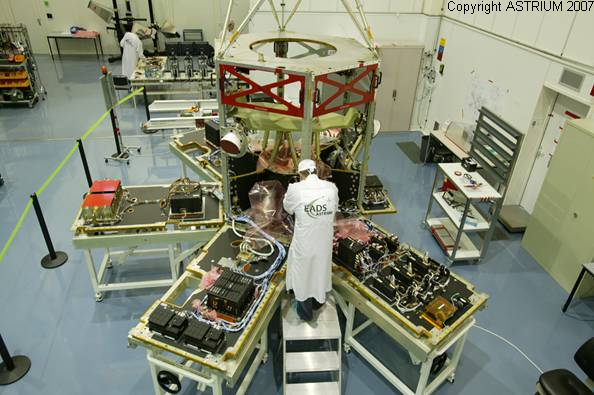
FREGAT fairing and the payload at S3B
07/2012: PLEIADES activated to help rescue teams in Russia
On Saturday 7th of July, torrential rains swept the Southern Russian Krasnodar region, killing more than 150 people. A foot of rain dropped in the Black Sea region forcing thousands of residents to scramble out of their beds seeking refuge on trees and rooftops.
The International Charter "Space and Major Disasters" was activated by USGS on behalf of ROSCOSMOS/EMERCOM of Russia to help rescue teams in their efforts with accurate geo-information from space.
Even though PLEIADES 1A, our recent Very-High-Resolution satellite is not yet in the Charter, CNES and Astrium Services jointly decided to exceptionally task the satellite to acquire images of the affected area, and effectively acquired cloud-free imagery on July 16th, which was delivered to the Charter shortly after acquisition.
Below is the photo-interpretation of the image realised by SERTIT.
06/26/2012: End of the Image Quality in-flight commissioning
06/04/2012: Beginning of the commercial distribution of PLEIADES images
03/03/2012: End of system in-flight commissioning
01/2012: A few images acquired by PLEIADES
![]()
![]()
Bora Bora island in Polynesia and San Francisco, Californie, USA
More images in the "Gallery".
EVENTS 2011
12/17/2011: Successful launch for PLEIADES and its companions
Soyouz lift off on December 17, 2011 by CNES
12/16/2011: PLEIADES satellite Launch by a Soyouz rocket from Kourou
11/29/2011: Operational Qualification Review
11/2011-12/2011: PLEIADES launch campaign in Kourou
11/03/2011: PLEIADES satellite departure for the launch campaign in Kourou
10/04/2011: Kick-off of the pre-launch campaign activities in Metropole
08/2011-09/2011: PLEIADES-HR1A satellite destorage
EVENTS 2010
09/2010: Preparatory Operational Qualification Review
EVENTS 2009
12/04/2009: Beginning of the System Technical Qualification Review
11/19/2009: Delivery by Thales Alenia Space of the instrument Flight Model 2 to Astrium
11/12/2009: Delivery by Astrium of the Satellite Flight Model 1 to CNES
09/2009: Rendez-vous between the satellite, the controle center (SDGC) and the mission centres for the complete system tests
02/2009-07/2009: The satellite Flight Model 1 successfully passed the environment tests at Intespace: thermal, mechanical, solar generators deploiment and electro-magnetic tests.
01/2009: Rendez-vous between the satellite, the controle center (SDGC) and the mission centres for the complete system tests
07/2008-11/2009: Satellite Assembly Integration and Tests (AIT)
EVENTS 2008
1st half of 2008: Satellite Assembly Integration and Tests (AIT)
EVENTS 2007
11/2007: First programming test of the satellite Flight Model 1
The programming message, generated with the first version newly commissionned of the Programming Chain, was executed on the Satellite Flight Model 1 (in integration at Astrium in Toulouse) and enabled to acquire about 250 images. These images, downloaded using on board equipments representative of the Pleiades X-band station, are being processed on the Imaging Chain, itself newly delivered to CNES.
The success of this test is very promissing and demonstrates a maturity level
07/2007: End of first bus integration
06/2007: Satellite Critical Design Review
EVENTS 2006
10/2006: Instrument Critical Design Review
06/2006: System Interface Review
02/2006: Multispectral filters flight model delivery
02/2006: Call for Tender for Users Centers Integration
EVENTS 2005
12/2005: Programming chain: the Software Specification Review was successful.
The authorisation to begin the preliminary design phase was given.
12/2005: Command Control chain: the Software Specification Review was successful
The authorisation to begin the preliminary design phase was given.
12/2005: The compatibility tests between image telemetry reception stations and the on board telemetry equipment were successful
11/2005: Users Centers Integration: The Preliminary Design Review took place
The preparation phase for the corresponding call for tender begins.
10/2005: Image chain: the Software Specification Review was successful
The authorisation to begin the preliminary design phase was given.
10/2005: Call for Tender for BPD/GIDE
10/2005: Multispectral detectors flight model delivery
06/2005: Attribution of the encrypting server for the TC link and the decipherer for the instrument TM contract to Thales-Com
06/2005: Attribution of the Ground Segment parts supplying contracts
- Programming chain: attributed to CAP Gemini - CSSI industrial consortium
- Image chain: attributed to Thales-IS
- Image receiving station: attributed to IN-SNEC
- Command-Control Center: attributed to CSSI
04/2005: Signature of the Agreement with Spain (Instituto Nacional de Tecnica Aerospacial)
03/2005: Signature of the Agreement with Sweden (Swedish Natioanl Space Board)
EVENTS 2004
12/2004: Attribution of the launch contract to Arianespace, for a launch by a Soyouz rocket from Kourou
09/2004: Ratification of the Turin agreement, signed in September 2001
03/2004: PLEIADES cooperation agreement signature with Sweden
EVENTS 2003
12/2003: ORFEO System Definition Review
10/2003: Satellites supplying contract signature with Astrium
05/22-05/23/2003: "Very High Spatial Resolution Workshop at CNES
04/01-04/02/2003: ORFEO users' seminar
02/2003: Pleiades-HR Instrument Preliminary Definition Review
EVENTS 2002
12/2002: Pleaides-HR System Design Review
05/28-05/29/2002: Pleaides internal seminar
04/2002: Pleaides-HR Satellite Preliminary Definition Review
03/2002: ORFEO Intermediate System Definition Review
EVENTS 2001
06/22/2001: Signature of a memorandum of agreement between CNES and ASI.
At the last Paris Air Show (June 2001), a memorandum of agreement was signed between the Centre National d'Etudes Spatiales (French space agency) and the Agenzia Spaziale Italiana (Italian space agency) for the definition phase of a Dual System with an Earth observation capability using optical satellites, radar satellites and an associated ground segment.
The Dual System to be developed is composed of the following elements:
- An optical component composed of 2 satellites and the corresponding ground functions, developed under french control,
- A radar component composed of 4 satellites and the corresponding ground functions, developed under italian control,
- A user ground segment developed jointly by France and Italy