Mission
Mission
Pleiades is the optical component of the ORFEO system developed in cooperation with Italy.
The Pleiades system is an optical observation system with a metric resolution designed to offer a high acquisition capability with a revisit lower than 24 hours to satisfy both civilian and military needs.
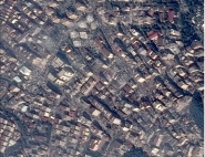
Moreover, to meet the needs for detailed mapping, especially in urban areas and to complement aerial photography, Pleiades will offer instantaneous stereoscopic acquisition and the capability to cover large areas.
For applications such as forestry, geology and marine environment, and using its spectral characteristics and its tree-dimensional characterization of surfaces, Pleiades should complete the information supplied by other sensors, such as Spot 5, by offering information with a better spatial resolution.
Lastly, to meet the defence and civil security missions, the Pleiades system is expected to:
- Supply the information in a very short time-frame (usually less than 24 hours).
- Ensure to defence users a priority in the daily programming of the 50 acquisition requests.
- Ensure to defence users the confidentiality of their requests and communications.
- Enable priority acquisitions on a predefined area with a "crisis" mode implementation.
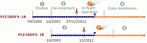
For this, the Pleiades system is constituted of a constellation of two optical satellites (visible and near infrared domain) on a Sun-synchronous orbit at 694 km. This number of satellites is essential to guarantee the accessibility and revisit frequency required to operationally answer to defence and civil security missions.
With its two agile satellites, the Pleiades system will offer:
- a daily access to every point on Earth,
- a resolution of 0.7 m in vertical viewing in panchromatic,
- four spectral bands (blue, green, red and near infrared) with a resolution of 2.8 m in vertical viewing,
- a field of view of 20 km,
- an acquisition of a 120 km x 120 km image mosaic in the same orbit,
- the acquisition of nearly instantaneous stereoscopic couples (or even triplet) of 20 km by 300 km,
- the acquisition of cloud free images covering 2 500 000 km² per year,
- a very accurate localization of the images (<1 m with ground control points) enabling an optimal use of the data in the Geographical Information Systems (GIS).
Moreover, the great agility of the satellites will enable to minimize the programming conflicts, particularly during the dual use, and to better meet the users' needs.
The main characteristics of the Pleiades optical component are in the table below:
| Image Specification | resolution field of view colour | 0.7 m 20 km blue, green, red and near infrared |
| Image Localization | with ground points without ground points | 1 m / 1000 km < 10 m |
| Acquisition Capabilities | km² by orbit (maxi) mosaic stereoscopy max target number on 100 km x 200 km | 30 000 km² 120 km x 120 km 20 km x 300 km 30 (crisis mode) |
![]()